Posts from — December 2009
“Turn Right at Groom Lake”
There were two incidents this weekend where people blindly followed their GPS into the middle of nowhere and were shocked when they got stuck in the snow, miles from a cell phone signal. It’s mind boggling that nothing would have tipped them off that it was a bad idea well before they got stuck. I would have known not to go that way as soon as it included “Forest Service” road anywhere in the directions. But beyond that, what about the fact that the road was probably completely unsigned, not to mention completely deserted? I was reluctant to take Oregon Highway 6 between Tillamook and Portland in March because of snow, yet these people think Forest Road 1234 is a good idea in December? Your four wheel drive is not going to protect you from your stupidity.
At any rate, it inspired me to see what kind of stupid directions I could have Google Maps give me. I’m a tester. Time to break stuff.
The obvious first choice is someplace where there aren’t roads, like Seattle to Tokyo. Apparently, the best route there is to drive to Gasworks Park, kayak to the north shore of Oahu, drive to Honolulu, then kayak the rest of the way to Japan. While I did appreciate that it specifically told me to kayak to Japan, and that it would take about 34 days to do so, I was a bit dismayed by the fact that it didn’t recommend a grand-circle route through the Aleutians, which should be faster and shorter, not to mention that you can drive to Homer Alaska, take the ferry to at least Kodiak, probably even further, then only have to kayak to somewhere in Siberia, where there’s probably a road of some sort down the Kamchatka Peninsula, then it’s another quick kayak trip across the Sea of Okhotsk to Japan. I guess they’re trying to keep me out of the dangerously stormy and cold North Pacific.
At any rate, I would be dead if I followed these directions because, well, you know, kayaking across the entire Pacific just ain’t gonna work out so well.
So then, I tried a more reasonable tourist query: How do I get to Windy Ridge from the Johnston Ridge Observatory at Mt. St. Helens? The correct answer is to go down through Cougar or up through Morton. That’s not what it told me. Now, I was hoping to be directed to take a road across the Blast Zone which hasn’t existed since 1980, but unfortunately, that was not the recommendation. Instead, I was given these directions:
| 3. | Slight left | Â |
361Â ft
|
| 4. | Turn left | Â |
0.6Â mi
|
| 5. | Turn right | Â |
2.7Â mi
|
| 6. | Turn left | Â |
0.6Â mi
|
| 7. | Turn left | Â |
1.4Â mi
|
| 8. | Turn right | Â |
2.3Â mi
|
| 9. | Turn left | Â |
0.3Â mi
|
| 10. | Turn left | Â |
1.1Â mi
|
| 11. | Slight right | Â |
0.4Â mi
|
| 12. | Turn right | Â |
0.7Â mi
|
| 13. | Slight left | Â |
2.2Â mi
|
| 14. | Turn left | Â |
1.4Â mi
|
| 15. | Turn right | Â |
0.6Â mi
|
Well, of course! Without these clear directions, I would have turned left at step 11, instead of a slight right, and who knows where I would have ended up. My DeLorme Gazetteer shows that somewhere out in that forest is where Bigfoot lives.
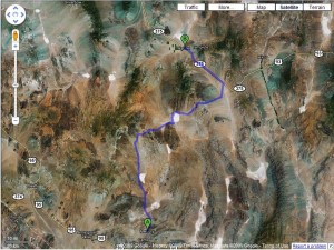
Now, the best set of directions I got were the ones between Mercury and Rachel, NV.  They’re tiny little specks of “civilization” on the Great Basin. Mercury is a former “company” town ((Where the company was the United States Atomic Energy Commission)) and Rachel is a bar and a handful of mobile homes in the middle of nowhere. There’s not much reason to go to either one (In fact, you can’t go to Mercury), and even less of a reason to drive between them, but I just wanted to see where I’d be sent. The results are awesome:
Here’s the directions Google gave me:
| 1. | Head north toward Mercury Hwy | Â |
0.3Â mi
|
| 2. | Turn right at Mercury Hwy | Â |
2.6Â mi
|
| 3. | Continue onto Short Pole Line Rd | Â |
2.4Â mi
|
| 4. | Slight left toward Mercury Hwy | Â |
2.2Â mi
|
| 5. | Continue straight onto Mercury Hwy | Â |
22.3Â mi
|
| 6. | Continue onto Mesa Rd | Â |
5.2Â mi
|
| 7. | Turn right at Groom Lake Rd | Â |
1.2Â mi
|
| 8. | Slight right toward Groom Lake Rd | Â |
0.9Â mi
|
| 9. | Continue straight onto Groom Lake Rd | Â |
2.5Â mi
|
| 10. | Slight right to stay on Groom Lake Rd | Â |
25.6Â mi
|
| 11. | Continue onto Groom Rd | Â |
13.0Â mi
|
| 12. | Turn left at Mail Box Rd | Â |
5.1Â mi
|
| 13. | Turn left at Extraterrestrial Hwy/NV-375 N | Â |
19.5Â mi
|
| 14. | Turn left at Canyon Rd | Â |
197Â ft
|
| 15. | Take the 1st right onto Front St | Â |
0.2Â mi
|
  Â
Allow me to enlighten you as to some of the scenery you’ll see along the way. Zoom in and follow the route.
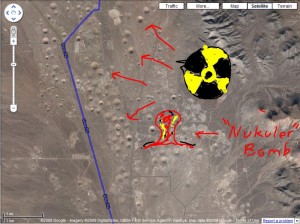
At about 20 miles or so, you’ll come across a valley full of craters. It’s not some cosmic impact zone. Instead, it’s the legacy of the Cold War. See, this area is where the government tested nuclear bombs from the 50’s through the early 90’s. There were some 1000 or so nuclear bombs set off in this area. After the early tests (you know, the ones you always see in the blast test movies) spread radiation across Eastern Nevada and a good chunk of Southern Utah (As well as other downwind points, even as far as Iowa and beyond), they decided it would be best to conduct the tests underground. These underground tests left subsidence craters all over this valley. If you’re following the route, the large crater that the road curves around at the north end of the valley is the result of the Sedan test, which was conducted as part of an experiment around using nuclear explosives for excavation work, you know, like for digging canals and such. As far as moving the earth, it was a spectacular success, forming the largest man-made crater ever, almost a quarter mile in diameter. Unfortunately, the experiment had a slight downside in that a large portion of the earth it moved ended up as radioactive dust which was carried by the winds across the country and exposed somewhere in the neighborhood of 15 million people to radioactive contamination.  Which would be why we don’t use nuclear bombs for road construction today…
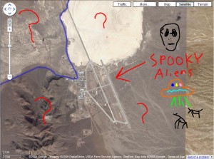
Drive around the Sedan Crater and over a mountain pass, and you’ll approach a cluster of buildings alongside a large dry lake bed. The lake is Groom Lake. THE Groom Lake. Those buildings are what’s known as Area 51. This is the primary reason why you’ll be shot if you try to take this road. Area 51 is, or, at least, was, one of the primary test sites for top secret military aircraft. It’s a perfect place for all sorts of clandestine activities, since it’s in the middle of nowhere and surrounded by even more nowhere. The nearest settlements outside the fence are backward holes in the wall, so if they see strange things flying by and start telling people, no one will believe them. The U2 and F117 Stealth Fighter were both developed here.
And we can’t forget the spooky aliens.
Anyway, keep driving through Dreamland, and make sure to take pictures of all the hangars, antenna arrays, huge satellite dishes, black helicopters, and all manner of other things that clearly do not exist and are easily confused with the planet Venus. Continue north, through the minefields and remote sensors and cameras, say hi to the nice people in the black SUV as you pass it by, and eventually you’ll come to the lone mailbox along the Extraterrestrial Highway (No, seriously, that’s the official state designation of the road) and you’re just a short distance from your final destination of Rachel.
I’m definitely going to take that drive the next time I’m in the area, because Google told me it’s the way to go!
December 30, 2009 No Comments


